Showing posts with label dams. Show all posts

Thursday, May 22, 2014

Challenge in Sao Paulo: Overcoming Water Scarcity in South America’s Largest City

Last March, one of Brazil’s most important newspapers, O Estado de S. Paulo, published a version of the article below, which summarizes the Conservancy’s efforts to help secure Sao Paulo’s water supply. It is translated and reprinted here with permission.

By João Campari and Samuel Barrêto, The Nature Conservancy

The inhabitants of Sao Paulo have been dealing with discouraging images of cracked riverbeds where they used to see flowing water, making this temperate part of Brazil look more like the country’s semi-arid region. Unfortunately, these stark images show the worsening struggles of the Cantareira system, one of the greatest water supply systems in the world.

Right now, the Cantareira’s reservoirs — responsible for providing water for more than 12 million inhabitants of the Sao Paulo Metropolitan Region (RMSP) and Campinas — are operating at less than 15% capacity*, the lowest level recorded since the Cantareira’s creation in the early 1970s.

The images, the symbol of the current crisis, show that water doesn’t really come from the taps in our houses. It comes from nature, and in Sao Paulo much of that nature is the Atlantic Forest. While water rationing gets peoples’ attention and is one of the necessary responses to water scarcity, rationing alone is not enough to solve the long-term problem of securing lasting access to fresh water.

We must look beyond the tap and work to take care of our water supplies at their sources. We need a systemic response for the management of watersheds to restore the sources of our water that have been degraded, polluted and deforested. Forests are very important for healthy fresh water supplies. Unfortunately, the Cantareira system alone has lost 70% of its original forest cover, aggravating the sedimentation of rivers and dams, and decreasing their ability to supply water.The degradation of native vegetation also worsens the effects of erosion and drought.

The interaction of all these factors — deforestation, sedimentation, erosion and drought — leads to a situation of extreme risk and represents an environmental, social and economic threat not just to Sao Paulo, but to the entire country of Brazil. The Sao Paulo Metropolitan Region and Campinas together are responsible for more then 22% of the country’s GDP. Therefore, it is a priority to create a strong and strategic response to the increasing and urgent problems of water quantity, quality, access and supply for urban centers.

Protecting Water Supplies at their Sources

We must go beyond conventional interventions, such as engineering works — more dams or aqueducts are not the answer. Wider, systemic responses are necessary, and the responsibility to act is not limited to the government. We all need water and it is the shared responsibility of businesses, communities and civil society as a whole to search for solutions together. The government’s role is to foster and implement multiple solutions that reach multiple stakeholders at once.

The Conservancy’s work shows that one of the highest priorities for securing Sao Paulo’s water supplies is strengthening the Cantareira system’s “green infrastructure” by restoring the degraded forests of the Atlantic Forest, as well as conserving existing forest remnants. Such initiatives ensure the health of a watershed. This type of solution, when well managed, minimizes the risk of extreme events and reduces the vulnerability of populations to floods and prolonged droughts. Healthy forests also store water and reduce erosion and provide environmental services of water regulation and security to the population.

New York City illustrates this equation quite clearly. Decades ago, the city’s administration compared the costs of both natural and built infrastructure for protecting and providing water. Preserving the forests that were source of the city’s drinking water cost US $1 to 1.5 billion over 10 years. That amount was seven times lessthan the estimated US $6 to 8 billion needed to build a traditional, engineered water treatment and distribution network. (That amount doesn’t include the additional and ongoing operational and maintenance costs of $300 to $500 million a year that would have been necessary.) Obviously, nature was the better buy for the people of New York.

It is something for Sao Paulo to consider. A recent study by the Conservancy showed that restoring about 35,000 acres of deforested areas and preventing erosion on 5000 acres within the basins of the Piracicaba, Capivari, Jundiaí and Alto Tietê rivers would decrease the level of sediments that clog the rivers by 50%. Reducing erosion would increase the capacity of water reservoirs and simultaneously decrease the cost of treatment for the removal of sediments.

What the Conservancy is doing in Sao Paulo

To help accomplish restoration goals in the lands around Sao Paulo’s Cantareira system, the Conservancy-led Water Producers Project provides payments to farmers and ranchers who conserve forests on properties that are part of the watershed that feeds the Cantareira reservoirs. This payment-for-environmental-services program recognizes and compensates landowners for the water-producing value their lands provide.

The Conservancy also leads the Water for Sao Paulo Movement. This initiative fosters conversation and working relationships between different stakeholders and focuses on the importance of both water conservation and nature-based solutions for securing the water supply of the region. Because healthy forests are so important for healthy rivers and water supplies, Water for Sao Paulo seeks to restore degraded forests near the urban area.

Finally, Sao Paulo must strengthen the existing Watersheds Committees. Created by the Brazilian Legislature, Watersheds Committees discuss and make decisions about the use of water from specific river basins and are some of the most important collaborations for achieving a balance between water supply and demand.Committees include representatives of local governments, water supply companies and civil society, who are responsible for tasks such as approving water management plans, defining actions for conservation of biodiversity and mediating conflicts about the use of water resources. There are more than 200 of these groups in Brazil.

The current crisis in the Cantareira system is both a challenge and an opportunity to learn from the past and make better decisions for the future. If we have the discernment to act in a systemic way and the political and institutional capacity for change, we will be able to reduce the risks of a permanent cycle of water shortage. In addition to this, we have the opportunity to show how healthy watersheds contribute to water security, which is indispensable for Sao Paulo’s social and economic stability into the future.

To learn more about how the Conservancy is helping to secure Brazil’s water supplies, please visit Where Does Your Water Come From?

*Since this article was published in March, the need for concerted action in Sao Paulo has become even more urgent. The level of water in the Cantareira system has now dropped – to about 8% of its overall capacity. As an emergency stopgap to provide water to the city, the government of Sao Paulo spent US$36 million on emergency constructions to allow access to water stored below the level of the pumps. Known to water managers as “dead volume,” this water was never intended to be part of the water supply, and the reservoirs are now, essentially, operating at a deficit. More


Monday, April 14, 2014

Quenching Kenya: Can New Water Discoveries Save East Africa?

Water scarcity is becoming the defining international crisis of the twenty-first century. Water conflicts rage across the world as communities struggle to secure a clean, reliable supply.

One of the world’s most water-stressed regions is East Africa. Overexploitation of water resources there has been compounded by declining snowpacks on Mount Kilimanjaro and Mount Kenya, which have shrunk since the late 1980s due to global warming. Meanwhile, Lake Turkana -- the world’s largest perennial desert lake -- has largely disappeared from Ethiopian territory, retreating south into Kenya.

In this light, the discovery of two significant aquifers in mostly arid Kenya by a Japanese-financed UNESCO project has been hailed as a potential game changer. The first, the Lotikipi Basin Aquifer, is situated just west of Lake Turkana. The second, the smaller Lodwar Basin Aquifer, is near Lodwar, the capital of Turkana county. The aquifers were discovered by a French firm, Radar Technologies International (RTI), using a space-based exploration technology called WATEX that was originally designed to reveal mineral deposits. The company blended satellite and radar imagery with geographical surveys and seismic data to detect moisture. Subsequent drilling by UNESCO confirmed the presence of aquifers. Three other suspected aquifers in the region have yet to be verified through drilling.

For parched and economically backward Turkana, more than one-third of whose residents are malnourished, the discovery of major groundwater reserves is a godsend. Not only will the reserves provide lifesaving water, they will also spur the development of agricultural and hydrocarbon sectors and improve the lives of the impoverished residents in this conflict-ridden region, which extends from Kenya into the borderlands of Ethiopia and South Sudan. More [Subscription]


Thursday, August 22, 2013

Littlest continent had biggest role in sea level drop [and rainfall]

A unique and complex set of circumstances came together over Australia from 2010 to 2011 to cause Earth's smallest continent to be the biggest contributor to the observed drop in global sea level rise during that time, finds a new study co-authored and co-funded by NASA.


In 2011, scientists at NASA's Jet Propulsion Laboratory in Pasadena, Calif., and the University of Colorado at Boulder reported that between early 2010 and summer 2011, global sea level fell sharply, by about a quarter of an inch, or half a centimeter. Using data from the NASA/German Aerospace Center's Gravity Recovery and Climate Experiment (GRACE) spacecraft, they showed that the drop was caused by the very strong La Nina that began in late 2010. That La Nina changed rainfall patterns all over our planet, moving huge amounts of Earth's water from the ocean to the continents. The phenomenon was short-lived, however.

By mid-2012, global mean sea level had resumed its long-term mean annual rise of 0.13 inches (3.2 millimeters) per year (see http://www.jpl.nasa.gov/news/news.php?release=2012-362).

But analyses of the historical record showed that past La Nina events only rarely accompanied such a pronounced drop in sea level. So what made this particular La Nina unique?

To better understand this phenomenon, scientists at the National Center for Atmospheric Research (NCAR) in Boulder, Colo.; JPL; and the University of Colorado at Boulder combined GRACE data with data from the Argo global array of 3,000 free-drifting floats and satellite altimeters (Jason-1, Jason-2 and Topex/Poseidon).

They found that three atmospheric patterns converged over the Indian and Pacific Oceans in 2010 and 2011 to drive excessive precipitation over Australia. On average, the continent received almost one foot (300 millimeters) of rain more than normal. The result was widespread flooding. The flooding was in large part prevented from running back into the ocean by Australia's dry soils and the mountain-ringed topography of the country's vast interior, called the Outback, leading to the measurable drop in the world's ocean levels.

"No other continent has this combination of atmospheric set-up and topography," said NCAR scientist John Fasullo, lead author of the study. "Only in Australia could the atmosphere carry such heavy tropical rains to such a large area, only to have those rains fail to make their way to the ocean."

Now that the atmospheric patterns have snapped back and more rain is falling over tropical oceans, the seas are rising again. In fact, with Australia in a major drought, they are rising faster than before. Since 2011, when the atmospheric patterns shifted out of their unusual combination, sea levels have been rising at a faster pace of about 0.4 inches (10 millimeters) per year.

The study, co-funded by NASA and the National Science Foundation, will be published next month in the journal Geophysical Research Letters.


Sunday, August 11, 2013

China and India 'water grab' dams put ecology of Himalayas in danger

The future of the world's most famous mountain range could be endangered by a vast dam-building project, as a risky regional race for water resources takes place in Asia.

Ranganadi hydroelectric project in Arunachal Pradesh

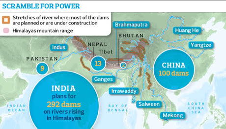
New academic research shows that India, Nepal, Bhutan and Pakistan are engaged in a huge "water grab" in the Himalayas, as they seek new sources of electricity to power their economies. Taken together, the countries have plans for more than 400 hydro dams which, if built, could together provide more than 160,000MW of electricity – three times more than the UK uses.

In addition, China has plans for around 100 dams to generate a similar amount of power from major rivers rising in Tibet. A further 60 or more dams are being planned for the Mekong river which also rises in Tibet and flows south through south-east Asia.

Most of the Himalayan rivers have been relatively untouched by dams near their sources. Now the two great Asian powers, India and China, are rushing to harness them as they cut through some of the world's deepest valleys. Many of the proposed dams would be among the tallest in the world, able to generate more than 4,000MW, as much as the Hoover dam on the Colorado river in the US.

The result, over the next 20 years, "could be that the Himalayas become the most dammed region in the world", said Ed Grumbine, visiting international scientist with the Chinese Academy of Sciences in Kunming. "India aims to construct 292 dams … doubling current hydropower capacity and contributing 6% to projected national energy needs. If all dams are constructed as proposed, in 28 of 32 major river valleys, the Indian Himalayas would have one of the highest average dam densities in the world, with one dam for every 32km of river channel. Every neighbour of India with undeveloped hydropower sites is building or planning to build multiple dams, totalling at minimum 129 projects," said Grumbine, author of a paper in Science.

China, which is building multiple dams on all the major rivers running off the Tibetan plateau, is likely to emerge as the ultimate controller of water for nearly 40% of the world's population. "The plateau is the source of the single largest collection of international rivers in the world, including the Mekong, the Brahmaputra, the Yangtse and the Yellow rivers. It is the headwater of rivers on which nearly half the world depends. The net effect of the dam building could be disastrous. We just don't know the consequences," said Tashi Tseri, a water resource researcher at the University of British Columbia in Canada.

"China is engaged in the greatest water grab in history. Not only is it damming the rivers on the plateau, it is financing and building mega-dams in Pakistan, Laos, Burma and elsewhere and making agreements to take the power," said Indian geopolitical analyst Brahma Chellaney. "China-India disputes have shifted from land to water. Water is the new divide and is going centre stage in politics. Only China has the capacity to build these mega-dams and the power to crush resistance. This is effectively war without a shot being fired."

According to Chellaney, India is in the weakest position because half its water comes directly from China; however, Bangladesh is fearful of India's plans for water diversions and hydropower. Bangladeshi government scientists say that even a 10% reduction in the water flow by India could dry out great areas of farmland for much of the year. More than 80% of Bangladesh's 50 million small farmers depend on water that flows through India.

Engineers and environmentalists say that little work has been done on the human or ecological impact of the dams, which they fear could increase floods and be vulnerable to earthquakes. "We do not have credible environmental and social impact assessments, we have no environmental compliance system, no cumulative impact assessment and no carrying capacity studies. The Indian ministry of environment and forests, developers and consultants are responsible for this mess," said Himanshu Thakkar, co-ordinator of South Asia Network on Dams, Rivers and People.

China and India have both displaced tens of millions of people with giant dams such as the Narmada and Three Gorges over the last 30 years, but governments have not published estimates of how many people would have to be relocated or how much land would be drowned by the new dams. "This is being totally ignored. No one knows, either, about the impact of climate change on the rivers. The dams are all being built in rivers that are fed by glaciers and snowfields which are melting at a fast rate," said Tsering.

Climate models suggest that major rivers running off the Himalayas, after increasing flows as glaciers melt, could lose 10-20% of their flow by 2050. This would not only reduce the rivers' capacity to produce electricity, but would exacerbate regional political tensions.

The dams have already led to protest movements in Uttarakhand, Himachal Pradesh, Sikkim, Assam and other northern states of India and in Tibet. Protests in Uttarakhand, which was devastated by floods last month, were led by Indian professor GD Agarwal, who was taken to hospital after a 50-day fast but who was released this week.

"There is no other way but to continue because the state government is not keen to review the dam policy," said Mallika Bhanot, a member of Ganga Avahan, a group opposing proposals for a series of dams on the Ganges.

Governments have tried to calm people by saying that many of the dams will not require large reservoirs, but will be "run of the river" constructions which channel water through tunnels to massive turbines. But critics say the damage done can be just as great. "[These] will complete shift the path of the river flow," said Shripad Dharmadhikary, a leading opponent of the Narmada dams and author of a report into Himalayan dams. "Everyone will be affected because the rivers will dry up between points. The whole hydrology of the rivers will be changed. It is likely to aggravate floods.

"A dam may only need 500 people to move because of submergence, but because the dams stop the river flow it could impact on 20,000 people. They also disrupt the groundwater flows so many people will end up with water running dry. There will be devastation of livelihoods along all the rivers." More


Friday, September 14, 2012

Flood Threat To Nuclear Plants Covered Up By Regulators, NRC Whistleblower Claims

In a letter submitted Friday afternoon to internal investigators at the Nuclear Regulatory Commission, a whistleblower engineer within the agency accused regulators of deliberately covering up information relating to the vulnerability of U.S. nuclear power facilities that sit downstream from large dams and reservoirs.

Fort Calhoun Nuclear Facility
The letter also accuses the agency of failing to act to correct these vulnerabilities despite being aware of the risks for years.

These charges were echoed in separate conversations with another risk engineer inside the agency who suggested that the vulnerability at one plant in particular -- the three-reactor Oconee Nuclear Station near Seneca, S.C. -- put it at risk of a flood and subsequent systems failure, should an upstream dam completely fail, that would be similar to the tsunami that hobbled the Fukushima Daiichi nuclear facility in Japan last year. That event caused multiple reactor meltdowns.

In the letter, a copy of which was obtained by The Huffington Post, Richard H. Perkins, a reliability and risk engineer with the agency's division of risk analysis, alleged that NRC officials falsely invoked security concerns in redacting large portions of a report detailing the agency's preliminary investigation into the potential for flooding at U.S. nuclear power plants due to upstream dam failure.

In addition to the Oconee facility, the report examined similar vulnerabilities at the Ft. Calhoun station in Nebraska, the Prairie Island facility in Minnesota and the Watts Bar plant in Tennessee, among others.

Perkins was the lead author of that report, which was completed in July of 2011 -- roughly four months after an earthquake and subsequent tsunami flooded the Fukushima Daiichi nuclear power plant in Japan, cut off electric power to the facility and disabled all of its backup power systems, eliminating the ability to keep the reactors cool and leading to a meltdown.

The report concluded, among other things, that the failure of one or more dams sitting upstream from several nuclear power plants "may result in flood levels at a site that render essential safety systems inoperable." High floodwaters could conceivably undermine all available power sources, the report found, including grid power, emergency diesel backup generators, and ultimately battery backups. The risk of these things happening, the report said, is higher than acceptable.

"The totality of information analyzed in this report suggests that external flooding due to upstream dam failure poses a larger than expected risk to plants and public safety," Perkins's report concluded, adding that the evidence warranted a more formal investigation.

In response to the report, the NRC launched an expanded investigation, which is ongoing. It also folded the dam failure issue into the slate of post-Fukushima improvements recommended by a special task force formed in the aftermath of that disaster. But in a press release dated March 6 of this year, the agency said the report "did not identify any immediate safety concerns."

The NRC made a heavily redacted copy of the report publicly available on the NRC website the same day.

"Nuclear power plant designs include protection against serious but very rare flooding events, including flooding from dam failure scenarios," the agency release noted. "Dam failures can occur as a consequence of earthquakes, overflow, and other mechanisms such as internal erosion and operational failures. A dam failure could potentially cause flooding at a nuclear power plant site depending on a number of factors including the location of the dam, reservoir volume, dam properties, flood routing, and site characteristics." More