Showing posts with label flooding. Show all posts

Wednesday, October 22, 2014

Mismanaging Climate Change

Pakistan’s extreme vulnerability to climate change is not a scientific secret but is, in fact, a logical certainty owing to its geographic location, inclined elevation, as well as demographics.

Former Minister Malik Amin Aslam Khan

The issue directly impacts upon the country’s already volatile water dynamics driven by the northern glaciers and the seasonal monsoon rains and, if not managed properly, could burden our economy to the tune of $6-14 billion per year (United Nations Framework Convention on Climate Change NEEDS study 2010). In response to this challenge, Pakistan’s National Climate Change Policy has laid out a comprehensive ‘to do’ list for the government, which was approved by the government but, unfortunately, has not been acted upon by the authorities. Oblivious to this apathy and inaction, Pakistan continues to face a mammoth challenge to not only climate-proof its future development path, but also take steps to cope with an issue, which is here to stay. These steps include establishing early warning systems, effective flood plain management, improving weather forecasting with cross-border data exchange and enhancing the disaster preparedness, as well as emergency response capabilities to deal with predicted climate-induced natural disasters.

To their credit, previous governments did begin to take concrete institutional building measures, such as establishing a very high-level Prime Minister’s Cabinet Committee on Climate Change, setting up a dedicated Ministry of Climate Change built on the debris of a misguidedly devolved Environment Ministry and creating a focused climate research centre i.e., the Global Change Impact Studies Centre. However, in one stroke of convenient denial, the present government has undone and dismantled all those measures by downgrading the ministry to a division level, drastically cutting the funds for the division, leaving it headless without an appointed minister and also drying up all finances for the climate research centre. It is, thus, not surprising, that the country received a rude wake-up call when, during the recent floods, the forces of nature once again caught it totally off guard and institutionally ill-prepared to deal with a situation, which had been predicted and forewarned time and again by climate experts.

The 2014 flood came in two surges. The first surge occurred due to exceptionally high rainfall in the rivers Jhelum, Chenab, Ravi and their catchments. It is a recorded fact that the Pakistan meteorological office gave clear warnings about this enhanced rainfall activity, which were not heeded to in a timely manner. The result of this negligence was that the Mangla Dam remained filled to the brim, while storm waters gathered upstream and, subsequently, the floodgates were forced open at the worst possible time when water levels were already dangerously peaking downstream. Had the water been incrementally released, as advised, the massive flood surge that eventually occurred could have been effectively prevented. Dams remain a double-edged sword — if used intelligently, they can be the best tool for controlling and regulating floods, but if used improperly, as they were on this occasion, they can quickly convert floods into mega human disasters.

This first human-induced deluge was followed by the second flood surge that occurred due to the unpredictably high ‘cloud-burst’ in Indian-held Kashmir. The information about this second surge was also received hours in advance as the water roared down River Chenab. Again, our own meteorological office issued a timely flood peak warning, but again, the reaction time and response measures of our government were found severely lacking.

The floods were triggered by climate-induced cloud-bursts and monsoonal shifts, but the human tragedy and destruction got multiplied due to poor government planning, human negligence and a criminal mixture of absence and apathy of relevant institutional response mechanisms.

Climate related calamities, including more flooding and an enhanced frequency of freak natural events are, unequivocally, predicted for Pakistan and it is time to take these warnings seriously, and for the government to heed to them by planning to deal with the consequences, limiting the damage and adapting to this shifting scenario. The recent floods, which are surely not the last one, have also rudely exposed the human, economic and environmental costs to be paid for our politically motivated aversion to building large dams, as well as the suicidal trend of encroaching upon flood plains and continuing to challenge the flood water boundaries.

Pakistan lies at the geographic crossroads of melting glaciers, shifting monsoons and enhanced disaster activity. This locational risk cannot be changed, but how we deal with this looming catastrophe can certainly be changed. What it requires is better responsive measures and heeding to technical advice and scientifically based warnings with timely decisions.

The political optics of wading through floodwaters and post disaster bear hugs with destitute and frustrated victims is beginning to lose its vote-gathering lustre. As we haplessly subject millions to avoidable disasters, it is time to face up to reality. Climate-proofing of infrastructure, conserving the yearly deluge of water that is callously flushed into the Arabian Sea and effectively enforced flood plains management needs to get the priority it deserves. The politics of underpasses and overpasses has to give way to the politics of common sense, based on what Pakistan’s real challenges are and what it is predicted to face up to in the near future. Governing with confused priorities and institutional mismanagement will continue to worsen the responses forced upon us as we face up to the unpredictability of climate change. More

Published in The Express Tribune, October 19th, 2014.


Monday, September 29, 2014

Explaining Extreme Events of 2013

A report released today investigates the causes of a wide variety of extreme weather and climate events from around the world in 2013. Published by the Bulletin of the American Meteorological Society, "Explaining Extreme Events of 2013 from a Climate Perspective (link is external)" addresses the causes of 16 individual extreme events that occurred on four continents in 2013. NOAA scientists served as three of the four lead editors on the report.

Of the five heat waves studied in the report, human-caused climate change was found to have clearly increased the severity and likelihood of those events. On the other hand, for other events examined like droughts, heavy rain events, and storms, fingerprinting the influence of human activity was more challenging. Human influence on these kinds of events—primarily through the burning of fossil fuels—was sometimes evident, but often less clear, suggesting natural factors played a far more dominant role.

"This annual report contributes to a growing field of science which helps communities, businesses and nations alike understand the impacts of natural and human-caused climate change," said Thomas R. Karl, L.H.D., director of NOAA’s National Climatic Data Center. "The science remains challenging, but the environmental intelligence it yields to decision makers is invaluable and the demand is ever-growing."

Confidence in the role of climate change about any one event is increased when multiple groups using independent methods come to similar conclusions. For example, in this report, five independent research teams looked at specific factors related to the record heat in Australia in 2013. Each consistently found that human-caused climate change increased the likelihood and severity of that event. However, for the California drought, which was investigated by three teams from the United States, human factors were found not to have influenced the lack of rainfall. One team found evidence that atmospheric pressure patterns increased due to human causes, but the influence on the California drought remains uncertain.

When human influence for an event cannot be conclusively identified with the scientific tools available today, this means that if there is a human contribution, it cannot be distinguished from natural climate variability.

"There is great scientific value in having multiple studies analyze the same extreme event to determine the underlying factors that may have influenced it," said Stephanie C. Herring, PhD, lead editor for the report at NOAA’s National Climatic Data Center. "Results from this report not only add to our body of knowledge about what drives extreme events, but what the odds are of these events happening again—and to what severity."

The report was edited by Herring, along with Martin P. Hoerling, NOAA’s Earth System Research Laboratory; Thomas Peterson, NOAA’s National Climatic Data Center, and Peter A. Stott, UK Met Office Hadley Centre and written by 92 scientists from 14 countries. View the full report online (link is external).

Also, view the slides for the media briefing on the "Explaining Extreme Events of 2013 from a Climate Perspective" report. More


Friday, August 29, 2014

A Traditional Future

Pakistani architect Yasmeen Lari uses local building techniques to rebuild villages in the flood-stricken Sindh region.

Yasmeen Lari - Architect

Yasmeen Lari is Pakistan’s first female architect and one of the most successful providers of disaster relief shelters in the world. She has built over 36,000 houses for victims of floods and earthquakes in Pakistan since 2010.

Shunning the structurally weak, mass-produced houses offered by international organisations, Lari uses vernacular techniques and local materials such as lime and bamboo. Her houses have a tiny carbon footprint and are simple enough for people to build themselves. With this, she hopes to demonstrate the role that architecture can play in humanitarian aid.

“I often tell my colleagues, let us not treat disaster-affected households as destitute, needing handouts … but with dignity,” she says.

Lari once built giant concrete and steel buildings for clients like the Pakistani State Oil company. But when disaster struck in 2005, she turned to traditional techniques to design flood and earthquake proof buildings for people in remote regions.

She returns to the Sindh region to see how her homes survived the 2013 floods and helps villagers in Awaran after the 2013 Balochistan earthquake.

Filmmaker’s view

By Faiza Ahmad Khan

Just a week before I left for Pakistan to film this documentary, the chief minister of my home state Rajasthan in India (which, incidentally, borders Sindh, the part of Pakistan that I was about to visit), pledged that within the next two years, there would be not a single mud house left standing in the state.

For many years the central government in India has already had a programme in place, which gives those in rural areas a sum of money to replace their traditional mud houses with brick and cement structures. Traditional is seen as poor and inferior and the fast track to “development” cannot, God forbid, be lined with mud and thatch houses.

While filming in Pakistan, I shared our chief minister’s announcement with an artisan who works with Yasmeen Lari at the Heritage Foundation in a village called Moak Sharif in Sindh.

“Thank God we’re decades behind India in this development business,” he said.

On one of my travels in Orissa in India, to a village called Govindpur that is resisting land acquisition for the mega steel company, POSCO, I met a woman who was rebuilding her kachcha house (made of natural materials, such as mud, bamboo and leave) despite being able to access government funding for a concrete house.

“We depend on this land for everything, we take what we know can be replenished. People in cities have no connection with the land so they don’t think twice about cutting down trees, mining the earth hollow. You think you’re separate from nature but you’re not. If this goes, you go,” she said.

What I am constantly being reminded of, as this country builds the capitalist dream, is that we stand to lose the wealth of traditional knowledge that pivots around this belief - ways to farm, heal, learn and live.

At the Heritage Foundation centre in Moak Sharif, Yasmeen Lari has been working to preserve traditional ways of building. The centre was set up by Yasmeen and her team in 2005 and has evolved to include a women’s centre, a small learning centre for children and a clinic to provide health care for the residents of the village.

Yasmeen believes that her role as an architect should not be restricted to designing houses and buildings. Instead, things should grow in an integrated way.

While I was there, they managed to get the government school, once barely functioning, in working order. Women from the village had organised themselves into a ‘mothers committee’ to oversee the school’s daily operations. And after I returned to India, every once in a while, Yasmeen would call and explain, with great delight, something new they were experimenting with – organic farming, bio fertilizers and natural soaps.

Through the making of this film I realised that building the “earth-way” means fluidity, not concreteness. It means working with the community, integrating it with structures of support and togetherness. Building homes, for Yasmeen, is about situating them. She guides her team to create this kind of space. Traditional, yes, but by no means can this approach be deemed irrelevant. More


Thursday, May 29, 2014

Putting Climate Polluters in the Dock

Can Caribbean governments take legal action against other countries that they believe are warming the planet with devastating consequences?

A former regional diplomat argues the answer is yes. Ronald Sanders, who is also a senior research fellow at London University, says such legal action would require all Small Island Developing States (SIDS) acting together.

He believes the Hague-based International Court of Justice (ICJ) would be amenable to hearing their arguments, although the court’s requirement that all parties to a dispute agree to its jurisdiction would be a major stumbling block.

“It is most unlikely that the countries that are warming the planet, which incidentally now include India and China, not just the United States, Canada and the European Union…[that] they would agree to jurisdiction,” Sanders told IPS.

“The alternative, if countries wanted to press the issue of compensation for the destruction caused by climate change, is that they would have to go to the United Nations General Assembly.”

Sanders said that the Caribbean Community (CARICOM) countries could “as a group put forward a resolution stating the case that they do believe, and there is evidence to support it, that climate change and global warming is having a material effect… on the integrity of their countries.

“We’re seeing coastal areas vanishing and we know that if sea level rise continues large parts of existing islands will disappear and some of them may even be submerged, so the evidence is there.”

Sanders pointed to the damaging effects of flooding and landslides in St. Vincent and the Grenadines, St. Lucia, and Dominica as 2013 came to an end.

The prime minister of St. Vincent and the Grenadines, Dr. Ralph Gonsalves, described the flooding and landslides as “unprecedented” and gave a preliminary estimate of damage in his country alone to be in excess of 60 million dollars.

“People who live in the Caribbean know from their own experience that climate change is real,” Sanders said.

“They know it from days and nights that are hotter than in the past, from more frequent and more intense hurricanes or freak years like the last one when there were none, from long periods of dry weather followed by unseasonal heavy rainfall and flooding, and from the recognisable erosion of coastal areas and reefs.”

At the U.N. climate talks in Warsaw last November, developing countries fought hard for the creation of a third pillar of a new climate treaty to be finalised in 2015. After two weeks and 36 straight hours of negotiations, they finally won the International Mechanism for Loss and Damage (IMLD), to go with the mitigation (emissions reduction) and adaptation pillars.

The details of that mechanism will be hammered out at climate talks in Bonn this June, and finally in Paris the following year. As chair of the Alliance of Small Island States (AOSIS), Nauru will be present at a meeting in New Delhi next week of the BASIC group (Brazil, South Africa, India and China) to try and build a common platform for the international talks.

“It isn’t just the Caribbean, of course,” Sanders said. “A number of other countries in the world – the Pacific countries – are facing an even more pressing danger than we are at the moment. There are countries in Africa that are facing this problem, and countries in Asia,” he told IPS.

“Now if they all join together, there is a moral case to be raised at the United Nations and maybe that is the place at which we would more effectively press it if we acted together. It would require great leadership, great courage and great unity,” he added.

Pointing to the OECD countries, Sir Ronald said they act together, consult with each other and come up with a programme which they then say is what the international standard must be and the developing countries must accept it.

“Why do the developing countries not understand that we could reverse that process? We can stand up together and say look, this is what we are demanding and the developed countries would then have to listen to what the developing countries are saying,” Sir Ronald said.

Following their recent 25th inter-sessional meeting in St. Vincent, Jamaican Prime Minister Portia Simpson Miller praised the increased focus that CARICOM leaders have placed on the issue of climate change, especially in light of the freak storm last year that devastated St. Lucia, Dominica and St. Vincent and the Grenadines.

At that meeting, heads of government agreed on the establishment of a task force on climate change and SIDS to provide guidance to Caribbean climate change negotiators, their ministers and political leaders in order to ensure the strategic positioning of the region in the negotiations.

In Antigua, where drought has persisted for months, water catchments are quickly drying up. The water manager at the state-owned Antigua Public utilities Authority (APUA), Ivan Rodrigues, blames climate change.

“We know that the climate is changing and what we need to do is to cater for it and deal with it,” he told IPS.

But he is not sold on the idea of international legal action against the large industrialised countries.

“I think what will cause [a reversal of their practices] is consumer activism,” he said. “The argument may not be strong enough for a court of law to actually penalise a government.”

But Sanders firmly believes an opinion from the International Court of Justice would make a huge difference.

“We could get an opinion. If the United Nations General Assembly were to accept a resolution that, say, we want an opinion from the International Court of Jurists on this matter, I think we could get an opinion that would be favourable to a case for the Caribbean and other countries that are affected by climate change,” he told IPS.

“If there was a case where countries, governments and large companies knew that if they continue these harmful practices, action would be taken against them, of course they would change their position because at the end of the day they want to be profitable and successful. They don’t want to be having to fight court cases and losing them and then having to pay compensation,” he added. More


Thursday, May 22, 2014

Challenge in Sao Paulo: Overcoming Water Scarcity in South America’s Largest City

Last March, one of Brazil’s most important newspapers, O Estado de S. Paulo, published a version of the article below, which summarizes the Conservancy’s efforts to help secure Sao Paulo’s water supply. It is translated and reprinted here with permission.

By João Campari and Samuel Barrêto, The Nature Conservancy

The inhabitants of Sao Paulo have been dealing with discouraging images of cracked riverbeds where they used to see flowing water, making this temperate part of Brazil look more like the country’s semi-arid region. Unfortunately, these stark images show the worsening struggles of the Cantareira system, one of the greatest water supply systems in the world.

Right now, the Cantareira’s reservoirs — responsible for providing water for more than 12 million inhabitants of the Sao Paulo Metropolitan Region (RMSP) and Campinas — are operating at less than 15% capacity*, the lowest level recorded since the Cantareira’s creation in the early 1970s.

The images, the symbol of the current crisis, show that water doesn’t really come from the taps in our houses. It comes from nature, and in Sao Paulo much of that nature is the Atlantic Forest. While water rationing gets peoples’ attention and is one of the necessary responses to water scarcity, rationing alone is not enough to solve the long-term problem of securing lasting access to fresh water.

We must look beyond the tap and work to take care of our water supplies at their sources. We need a systemic response for the management of watersheds to restore the sources of our water that have been degraded, polluted and deforested. Forests are very important for healthy fresh water supplies. Unfortunately, the Cantareira system alone has lost 70% of its original forest cover, aggravating the sedimentation of rivers and dams, and decreasing their ability to supply water.The degradation of native vegetation also worsens the effects of erosion and drought.

The interaction of all these factors — deforestation, sedimentation, erosion and drought — leads to a situation of extreme risk and represents an environmental, social and economic threat not just to Sao Paulo, but to the entire country of Brazil. The Sao Paulo Metropolitan Region and Campinas together are responsible for more then 22% of the country’s GDP. Therefore, it is a priority to create a strong and strategic response to the increasing and urgent problems of water quantity, quality, access and supply for urban centers.

Protecting Water Supplies at their Sources

We must go beyond conventional interventions, such as engineering works — more dams or aqueducts are not the answer. Wider, systemic responses are necessary, and the responsibility to act is not limited to the government. We all need water and it is the shared responsibility of businesses, communities and civil society as a whole to search for solutions together. The government’s role is to foster and implement multiple solutions that reach multiple stakeholders at once.

The Conservancy’s work shows that one of the highest priorities for securing Sao Paulo’s water supplies is strengthening the Cantareira system’s “green infrastructure” by restoring the degraded forests of the Atlantic Forest, as well as conserving existing forest remnants. Such initiatives ensure the health of a watershed. This type of solution, when well managed, minimizes the risk of extreme events and reduces the vulnerability of populations to floods and prolonged droughts. Healthy forests also store water and reduce erosion and provide environmental services of water regulation and security to the population.

New York City illustrates this equation quite clearly. Decades ago, the city’s administration compared the costs of both natural and built infrastructure for protecting and providing water. Preserving the forests that were source of the city’s drinking water cost US $1 to 1.5 billion over 10 years. That amount was seven times lessthan the estimated US $6 to 8 billion needed to build a traditional, engineered water treatment and distribution network. (That amount doesn’t include the additional and ongoing operational and maintenance costs of $300 to $500 million a year that would have been necessary.) Obviously, nature was the better buy for the people of New York.

It is something for Sao Paulo to consider. A recent study by the Conservancy showed that restoring about 35,000 acres of deforested areas and preventing erosion on 5000 acres within the basins of the Piracicaba, Capivari, Jundiaí and Alto Tietê rivers would decrease the level of sediments that clog the rivers by 50%. Reducing erosion would increase the capacity of water reservoirs and simultaneously decrease the cost of treatment for the removal of sediments.

What the Conservancy is doing in Sao Paulo

To help accomplish restoration goals in the lands around Sao Paulo’s Cantareira system, the Conservancy-led Water Producers Project provides payments to farmers and ranchers who conserve forests on properties that are part of the watershed that feeds the Cantareira reservoirs. This payment-for-environmental-services program recognizes and compensates landowners for the water-producing value their lands provide.

The Conservancy also leads the Water for Sao Paulo Movement. This initiative fosters conversation and working relationships between different stakeholders and focuses on the importance of both water conservation and nature-based solutions for securing the water supply of the region. Because healthy forests are so important for healthy rivers and water supplies, Water for Sao Paulo seeks to restore degraded forests near the urban area.

Finally, Sao Paulo must strengthen the existing Watersheds Committees. Created by the Brazilian Legislature, Watersheds Committees discuss and make decisions about the use of water from specific river basins and are some of the most important collaborations for achieving a balance between water supply and demand.Committees include representatives of local governments, water supply companies and civil society, who are responsible for tasks such as approving water management plans, defining actions for conservation of biodiversity and mediating conflicts about the use of water resources. There are more than 200 of these groups in Brazil.

The current crisis in the Cantareira system is both a challenge and an opportunity to learn from the past and make better decisions for the future. If we have the discernment to act in a systemic way and the political and institutional capacity for change, we will be able to reduce the risks of a permanent cycle of water shortage. In addition to this, we have the opportunity to show how healthy watersheds contribute to water security, which is indispensable for Sao Paulo’s social and economic stability into the future.

To learn more about how the Conservancy is helping to secure Brazil’s water supplies, please visit Where Does Your Water Come From?

*Since this article was published in March, the need for concerted action in Sao Paulo has become even more urgent. The level of water in the Cantareira system has now dropped – to about 8% of its overall capacity. As an emergency stopgap to provide water to the city, the government of Sao Paulo spent US$36 million on emergency constructions to allow access to water stored below the level of the pumps. Known to water managers as “dead volume,” this water was never intended to be part of the water supply, and the reservoirs are now, essentially, operating at a deficit. More


Monday, March 17, 2014

Climate change: Leaked draft of UN IPCC report predicts global warming will cause violent conflict, displace millions of people and wipe trillions of dollars off the global economy

Climate change will displace hundreds of millions of people by the end of this century, increasing the risk of violent conflict and wiping trillions of dollars off the global economy, a forthcoming UN report will warn.

The second of three publications by the UN’s Intergovernmental Panel on Climate Change, due to be made public at the end of this month, is the most comprehensive investigation into the impact of climate change ever undertaken. A draft of the final version seen by The Independent says the warming climate will place the world under enormous strain, forcing mass migration, especially in Asia, and increasing the risk of violent conflict.

Based on thousands of peer-reviewed studies and put together by hundreds of respected scientists, the report predicts that climate change will reduce median crop yields by 2 per cent per decade for the rest of the century – at a time of rapidly growing demand for food. This will in turn push up malnutrition in children by about a fifth, it predicts.

Climate change


The report also forecasts that the warming climate will take its toll on human health, pushing up the number of intense heatwaves and fires and increasing the risk from food and water-borne diseases.

While the impact on the UK will be relatively small, global issues such as rising food prices will pose serious problems. Britain’s health and environmental “cultural heritage” is also likely to be hurt, the report warns.

According to the draft report, a rare grassy coastal habitat unique to Scotland and Ireland is set to suffer, as are grouse moors in the UK and peatlands in Ireland. The UK’s already elevated air pollution is likely to worsen as burning fossil fuels increase ozone levels, while warmer weather will increase the incidence of asthma and hay fever.

Coastal systems and low-lying areas

The report predicts that by the end of the century “hundreds of millions of people will be affected by coastal flooding and displaced due to land loss”. The majority affected will be in East Asia, South-east Asia and South Asia. Rising sea levels mean coastal systems and low-lying areas will increasingly experience submergence, coastal flooding and coastal erosion.

Food security

Relatively low local temperature increases of 1C or more above pre-industralised levels are projected to “negatively impact” yields of major crops such as wheat, rice and maize in tropical and temperate regions. The report forecasts that climate change will reduce median yields by up to 2 per cent per decade for the rest of the century – against a backdrop of rising demand that is set to increase by 14 per cent per decade until 2050.

The global economy

A global mean temperature increase of 2.5C above pre-industrial levels may lead to global aggregate economic losses of between 0.2 and 2.0 per cent, the report warns. Global GDP was $71.8trn (£43.1trn) in 2012, meaning a 2 per cent reduction would wipe $1.4trn off the world’s economic output that year.

Human health

Until mid-century, climate change will impact human health mainly by exacerbating problems that already exist, the report says. Climate change will lead to increases in ill-health in many regions, with examples including a greater likelihood of injury, disease and death due to more intense heatwaves and fires; increased likelihood of under-nutrition; and increased risks from food and water-borne diseases. Without accelerated investment in planned adaptations, climate change by 2050 would increase the number of undernourished children under the age of five by 20-25 million globally, or by 17-22 per cent, it says.

Human security

Climate change over the 21st century will have a significant impact on forms of migration that compromise human security, the report states. For example, it indirectly increases the risks from violent conflict in the form of civil war, inter-group violence and violent protests by exacerbating well-established drivers of these conflicts such as poverty and economic shocks.

Small-island states and other places highly vulnerable to sea-level rise face major challenges to their territorial integrity. Some “transboundary” impacts of climate change, such as changes in sea ice, shared water resources and migration of fish stocks have the potential to increase rivalry among states.

Freshwater resources

The draft of the report says “freshwater-related risks of climate change increase significantly with increasing greenhouse gas emissions”. It finds that climate change will “reduce renewable surface water and groundwater resources significantly in most dry subtropical regions”, exacerbating the competition for water. Terrestrial and freshwater species will also face an increased extinction risk under projected climate change during and beyond the 21st century.

Unique landscapes

Machair, a grassy coastal habitat found only in north-west Scotland and the west coast of Ireland, is one of the several elements of the UK’s “cultural heritage” that is at risk from climate change, the report says. Machair is found only on west-facing shores and is rich in calcium carbonate derived from crushed seashells. It is so rare and special, that a recent assessment by the European Forum on Nature Conservation and Pastoralism described it as an “unknown jewel”.

The IPCC also warns of climate threats to Irish peatlands and UK grousemoors and notes an increasing risk to health across Europe from rising air pollution – in which the polluted UK is already in serial breach of EU regulations. More


Sunday, February 16, 2014

Study: Climate change linked to extreme rain

John Fogerty once crooned "Who'll stop the rain?" Not humanity, apparently, as new research shows that human-caused climate change has significantly increased the chances of extreme rain- and snowfall around the world, along with the deadly floods that follow.

Pakistan floods 2011

This is according to two new studies published Wednesday in the British journal Nature.

While other studies have suggested that global warming may be partly responsible for an increase in heavy precipitation, what's new in this study is the formal finding that human influence has "likely made intense precipitation stronger, on average, over the second half of the 20th century," says study co-author Francis Zwiers of the University of Victoria in British Columbia.

"The observed change cannot be explained by natural fluctuations of the climate system alone," he says.

One of the studies reported that that the most significant rain and snow events were 7 percent wetter in the 1990s than they had been in the 1950s.

Scientists based their findings on rainfall data from 1951 to 1999 in Northern Hemisphere land areas, including North America, Eurasia and India.

The scientists took all the information that showed an increase in extreme rain and snow events from the 1950s through the 1990s, and ran dozens of computer models numerous times. They put in the effects of greenhouse gases -- which come from the burning of fossil fuels -- and then ran numerous models without those factors.

Only when the greenhouse gases are factored in did the models show a similar increase to what actually happened. Essentially, the computer runs show climate change is the only way to explain what's happening.

The other study dealt with the floods that swamped the U.K. in fall 2000 and determined that climate change made them over twice as likely to occur.

Why would global warming lead to more precipitation? According to study co-author Myles Allen of the University of Oxford in England, warmer air holds more water.

Senior scientist Kevin Trenberth of the National Center for Atmospheric Research in Boulder, who was not part of either study, expands on this: "The water holding capacity of the atmosphere goes up with higher temperatures (and higher sea-surface temperatures), and so there is simply more moisture lurking around waiting to be caught up in any storm."

The effects of greenhouse gases on precipitation appear to be global: "Extreme precipitation is expected to increase almost everywhere in a warmer world, even though we expect reductions in mean precipitation in some locations and increases in others," reports Zwiers.

Overall, according to Zwiers, computer models suggest that the northern high latitudes will see the largest percentage increases in mean annual precipitation, and that the tropics will see the largest percentage increases in extreme precipitation.

"Damaging weather events have always happened since well before humans had any substantial influence on climate," says Allen. "This research allows us to quantify how rising greenhouse gas levels may be loading the dice in favor of certain events, such as the U.K. floods of 2000, and against other events."

However, climate scientist Jerry North of Texas A&M University, while praising the work, said he worried that the studies were making too firm a connection based on weather data that could be poor in some locations. More


Wednesday, October 2, 2013

Monsoon to get longer in India [sub-continent]: IPCC

NEW DELHI: North India is likely to heat up more than the southern parts of the country while the entire Indian subcontinent may see longer rainy seasons in second half of the century, the UN's climate body has predicted in its latest comprehensive document on climate change.


The conclusion, showing variation in temperature and rainfall in South Asia, is part of the lengthy technical details of the United Nation's Intergovernmental Panel on Climate Change (IPCC) which made its comprehensive report — Climate Change 2013, The Physical Science Basis — public in Stockholm on Monday.

The findings of the report show that the northern part of the continent is likely to witness winter temperatures rise of up to 0.4 to 0.8 degree Celsius during 2016-35 as compared to the 1986-2005 average, 2 to 3 degree Celsius during 2046-65 and up to 3 to 5 degree Celsius by the end of the century (2081-2100), under different scenarios of action to limit greenhouse gas emissions.

Though the UN body's report on region-wise "impact, adaptation and vulnerability" will come out in March next year, the technical details comprising 14 chapters and Atlas of Global and Regional Climate Projections in its annexure carry indications of these changes in South Asia.

Krishna Kumar Kanikicharla, climate scientist at Pune's Indian Institute of Tropical Meteorology and one of the drafting authors of the IPCC report, told TOI there was "growing evidence" of the impact of the climate change on monsoons in South Asia and the tropical cyclone system in the Bay of Bengal.

Kanikicharla, responsible for drafting the chapter comprising details of monsoon systems, said: "There is strong hint that the duration of the rainy season would increase due to early onset of monsoon. The quantum of rainfall will also increase during the later part of this century."

He said though the Indian summer monsoon circulation will weaken, rainfall will increase due to higher atmospheric moisture resulting from a rise in temperatures.

In its projection for South Asia, the technical summary of the report clearly points at "enhanced summer monsoon precipitation and increased rainfall extremes of landfall cyclones on the coasts of the Bay of Bengal and Arabian Sea".

What is the confidence level of these predictions? Prashant Goswami, one of the lead authors of the IPCC report, admitted that these conclusions were based on climatic projections that were not as firm as those made at a global level.

"These uncertainties increase as you go to smaller scale (from global to regional or from regional to sub-regional levels). But one has to have an element of faith in these conclusions which are based on well defined scientific methodology," Goswami, chief scientist at Bangalore's CSIR Centre for Mathematical Modelling and Computer Simulation, told TOI.

The impact of temperature rise and rainfall variations on the region's agriculture that's highly dependent on monsoon, will be considered in the report on impact, adaptation and vulnerability, to be released next year as part of the IPCC's fifth assessment report (AR5). More


Thursday, August 22, 2013

Littlest continent had biggest role in sea level drop [and rainfall]

A unique and complex set of circumstances came together over Australia from 2010 to 2011 to cause Earth's smallest continent to be the biggest contributor to the observed drop in global sea level rise during that time, finds a new study co-authored and co-funded by NASA.


In 2011, scientists at NASA's Jet Propulsion Laboratory in Pasadena, Calif., and the University of Colorado at Boulder reported that between early 2010 and summer 2011, global sea level fell sharply, by about a quarter of an inch, or half a centimeter. Using data from the NASA/German Aerospace Center's Gravity Recovery and Climate Experiment (GRACE) spacecraft, they showed that the drop was caused by the very strong La Nina that began in late 2010. That La Nina changed rainfall patterns all over our planet, moving huge amounts of Earth's water from the ocean to the continents. The phenomenon was short-lived, however.

By mid-2012, global mean sea level had resumed its long-term mean annual rise of 0.13 inches (3.2 millimeters) per year (see http://www.jpl.nasa.gov/news/news.php?release=2012-362).

But analyses of the historical record showed that past La Nina events only rarely accompanied such a pronounced drop in sea level. So what made this particular La Nina unique?

To better understand this phenomenon, scientists at the National Center for Atmospheric Research (NCAR) in Boulder, Colo.; JPL; and the University of Colorado at Boulder combined GRACE data with data from the Argo global array of 3,000 free-drifting floats and satellite altimeters (Jason-1, Jason-2 and Topex/Poseidon).

They found that three atmospheric patterns converged over the Indian and Pacific Oceans in 2010 and 2011 to drive excessive precipitation over Australia. On average, the continent received almost one foot (300 millimeters) of rain more than normal. The result was widespread flooding. The flooding was in large part prevented from running back into the ocean by Australia's dry soils and the mountain-ringed topography of the country's vast interior, called the Outback, leading to the measurable drop in the world's ocean levels.

"No other continent has this combination of atmospheric set-up and topography," said NCAR scientist John Fasullo, lead author of the study. "Only in Australia could the atmosphere carry such heavy tropical rains to such a large area, only to have those rains fail to make their way to the ocean."

Now that the atmospheric patterns have snapped back and more rain is falling over tropical oceans, the seas are rising again. In fact, with Australia in a major drought, they are rising faster than before. Since 2011, when the atmospheric patterns shifted out of their unusual combination, sea levels have been rising at a faster pace of about 0.4 inches (10 millimeters) per year.

The study, co-funded by NASA and the National Science Foundation, will be published next month in the journal Geophysical Research Letters.


Sunday, August 11, 2013

China and India 'water grab' dams put ecology of Himalayas in danger

The future of the world's most famous mountain range could be endangered by a vast dam-building project, as a risky regional race for water resources takes place in Asia.

Ranganadi hydroelectric project in Arunachal Pradesh

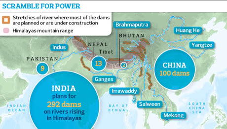
New academic research shows that India, Nepal, Bhutan and Pakistan are engaged in a huge "water grab" in the Himalayas, as they seek new sources of electricity to power their economies. Taken together, the countries have plans for more than 400 hydro dams which, if built, could together provide more than 160,000MW of electricity – three times more than the UK uses.

In addition, China has plans for around 100 dams to generate a similar amount of power from major rivers rising in Tibet. A further 60 or more dams are being planned for the Mekong river which also rises in Tibet and flows south through south-east Asia.

Most of the Himalayan rivers have been relatively untouched by dams near their sources. Now the two great Asian powers, India and China, are rushing to harness them as they cut through some of the world's deepest valleys. Many of the proposed dams would be among the tallest in the world, able to generate more than 4,000MW, as much as the Hoover dam on the Colorado river in the US.

The result, over the next 20 years, "could be that the Himalayas become the most dammed region in the world", said Ed Grumbine, visiting international scientist with the Chinese Academy of Sciences in Kunming. "India aims to construct 292 dams … doubling current hydropower capacity and contributing 6% to projected national energy needs. If all dams are constructed as proposed, in 28 of 32 major river valleys, the Indian Himalayas would have one of the highest average dam densities in the world, with one dam for every 32km of river channel. Every neighbour of India with undeveloped hydropower sites is building or planning to build multiple dams, totalling at minimum 129 projects," said Grumbine, author of a paper in Science.

China, which is building multiple dams on all the major rivers running off the Tibetan plateau, is likely to emerge as the ultimate controller of water for nearly 40% of the world's population. "The plateau is the source of the single largest collection of international rivers in the world, including the Mekong, the Brahmaputra, the Yangtse and the Yellow rivers. It is the headwater of rivers on which nearly half the world depends. The net effect of the dam building could be disastrous. We just don't know the consequences," said Tashi Tseri, a water resource researcher at the University of British Columbia in Canada.

"China is engaged in the greatest water grab in history. Not only is it damming the rivers on the plateau, it is financing and building mega-dams in Pakistan, Laos, Burma and elsewhere and making agreements to take the power," said Indian geopolitical analyst Brahma Chellaney. "China-India disputes have shifted from land to water. Water is the new divide and is going centre stage in politics. Only China has the capacity to build these mega-dams and the power to crush resistance. This is effectively war without a shot being fired."

According to Chellaney, India is in the weakest position because half its water comes directly from China; however, Bangladesh is fearful of India's plans for water diversions and hydropower. Bangladeshi government scientists say that even a 10% reduction in the water flow by India could dry out great areas of farmland for much of the year. More than 80% of Bangladesh's 50 million small farmers depend on water that flows through India.

Engineers and environmentalists say that little work has been done on the human or ecological impact of the dams, which they fear could increase floods and be vulnerable to earthquakes. "We do not have credible environmental and social impact assessments, we have no environmental compliance system, no cumulative impact assessment and no carrying capacity studies. The Indian ministry of environment and forests, developers and consultants are responsible for this mess," said Himanshu Thakkar, co-ordinator of South Asia Network on Dams, Rivers and People.

China and India have both displaced tens of millions of people with giant dams such as the Narmada and Three Gorges over the last 30 years, but governments have not published estimates of how many people would have to be relocated or how much land would be drowned by the new dams. "This is being totally ignored. No one knows, either, about the impact of climate change on the rivers. The dams are all being built in rivers that are fed by glaciers and snowfields which are melting at a fast rate," said Tsering.

Climate models suggest that major rivers running off the Himalayas, after increasing flows as glaciers melt, could lose 10-20% of their flow by 2050. This would not only reduce the rivers' capacity to produce electricity, but would exacerbate regional political tensions.

The dams have already led to protest movements in Uttarakhand, Himachal Pradesh, Sikkim, Assam and other northern states of India and in Tibet. Protests in Uttarakhand, which was devastated by floods last month, were led by Indian professor GD Agarwal, who was taken to hospital after a 50-day fast but who was released this week.

"There is no other way but to continue because the state government is not keen to review the dam policy," said Mallika Bhanot, a member of Ganga Avahan, a group opposing proposals for a series of dams on the Ganges.

Governments have tried to calm people by saying that many of the dams will not require large reservoirs, but will be "run of the river" constructions which channel water through tunnels to massive turbines. But critics say the damage done can be just as great. "[These] will complete shift the path of the river flow," said Shripad Dharmadhikary, a leading opponent of the Narmada dams and author of a report into Himalayan dams. "Everyone will be affected because the rivers will dry up between points. The whole hydrology of the rivers will be changed. It is likely to aggravate floods.

"A dam may only need 500 people to move because of submergence, but because the dams stop the river flow it could impact on 20,000 people. They also disrupt the groundwater flows so many people will end up with water running dry. There will be devastation of livelihoods along all the rivers." More


Sunday, July 28, 2013

Rivers' in air could boost flooding

Winter floods could intensify in Britain, [and countries globally] according to new research into powerful weather systems called "atmospheric rivers".

Only identified about 20 years ago, atmospheric rivers are intense bands of moisture that flow through the air.

Known to be responsible for heavy rainfall, they have been blamed for severe flooding in California and the UK.

The new study suggests that warmer conditions could create more rivers - and make them more severe.

The paper is published by the Institute of Physics in Environmental Research Letters.

Atmospheric rivers are up to 300km wide and can stretch in length for over 1,000-2,000km. They flow invisibly between 1-2.5km above the surface of the ocean.

One atmospheric river is believed to have been behind the violent flooding that hit Cockermouth in Cumbria on 19 November 2009.

The flooding claimed the life of a policeman, PC Bill Barker, who died after a bridge collapsed.

The researchers, led by Dr David Lavers of the University of Iowa, have estimated the staggering volume of moisture carried by this particular atmospheric river.

They calculate that at its peak it was transporting almost 300,000 tonnes of moisture every second.

By comparison, the River Thames carries about 65 tonnes of water through London over the same period.

Remain on course

If the rivers make landfall and encounter a steep rise in terrain, the air is forced upwards where it cools and releases the moisture in the form of rain.

On top of that, if the river remains on the same course for 24 hours - as it did over Cumbria in 2009 - it will deliver a continuous flow of heavy rain over the same area.

The most closely-studied atmospheric river, which flows towards the California coast, has been dubbed the "Pineapple Express" because it usually originates from the region of Hawaii.

It has been linked to a number of extremely damaging storms along the US West Coast.

Over the last 30 years, there has been an average of 9-11 of the strongest atmospheric river events hitting Britain every year.

In this latest study, the researchers examined five different modelling scenarios to simulate possible conditions this century and found that a warming climate - which allows the atmosphere to hold more moisture - made the rivers more likely.

Dr Lavers said: "All five models suggest that there could be a doubling of atmospheric river events in the period 2074-99 and most of those could be expected to make landfall in the UK.

"One of the big things is that these are the most relevant feature of winter flooding in Britain and the work is certainly suggesting an increase in strength and frequency."

Computer modelling

Among the uncertainties about the research are the reliability of the models used to generate the future scenarios and possible shifts in the patterns of the winds - a change of course away from the UK would reduce the risk.

It was research in the 1970s that first identified "conveyor belts" of moisture travelling through the atmosphere, with later studies in the early 1990s detecting much narrower bands of intense vapour that became known as atmospheric rivers.

Dr Richard Allan of Reading University, also an author of the paper, said: "What this shows is that the dominating factor is the increase in water vapour which means that if you've got more moisture - and the winds don't change -then you've got a much bigger potential for flooding.

"These are really massive flows of invisible water which can feed clouds and cause rainfall if forced up over mountains."

The researchers say the study could help guide forecasters trying to give warning of future flood risks. More