Showing posts with label nepal. Show all posts

Monday, May 11, 2015

Superadobe/Earthbag Orphanage Withstands Nepal Earthquake

Cal-Earth Low-cost Sustainable Earthen Housing Solutions Proved Effective and Safe in Earthquakes

Hesperia, Calif., May 5, 2015 -- Cal-Earth Institute today announced they received confirmation that the Superadobe/Earthbag orphanage project built for the Pegasus Children’s Project in the northern Khathmandu valley in Nepal survived the 7.6 magnitude earthquake on 25 April 2015, and the structures are all still standing.

The Superadobe (sandbags/barbed wire) building system developed at Cal-Earth (U.S. Patent #5,934,027) integrates traditional earth architecture with contemporary global safety requirements, and passes severe earthquake code tests in California. The technology has been published by NASA, endorsed by the United Nations, featured in countless world media outlets, and awarded the prestigious Aga Khan Award for Architecture in 2004.

A UK organization, Small Earth, built over 40 domes in 2006 for the Pegasus Children’s Project in Nepal, which is home to over 90 children and their caretakers, all of who are confirmed safe after the earthquake. Trained by a Cal-Earth alumni in 2005, Small Earth’s founder, Julian Faulkner, shared the news: "The domes have come through relatively unscathed with just surface cracking to the plasterwork… in the village below the site 15 houses have collapsed and many others are badly damaged with all the villagers now sleeping under tarpaulins in the fields."

Faulkner stated the superficial damage to the buildings is a "testament to the quality of training we received that has enabled us to further develop the technology for use in climates as diverse as the temperate UK, the monsoon-drenched Himalayas and the African savannah." Pegasus is raising funds to rebuild a brick structure that was destroyed during the quake, but feel validated in their choice to build earthbag domes to withstand the extreme conditions.

The Cal-Earth organization is dedicated to addressing the pressing needs of all the Earth’s homeless population and displaced people. The global housing shortage currently includes some 20-40 million refugees and displaced persons, and hundreds of millions more who live in substandard or slum housing. With compounding environmental challenges and the acceleration of natural and man-made disasters, this shortage will only become more severe in the coming decades. Cal-Earth believes the time to act is now, in order to ensure that everyone has a safe and sustainable place to live.

Cal-Earth is responding to the growing need to educate people in the face of compounding environmental challenges and the acceleration of natural and man-made disasters. On May 11, 2015, Cal-Earth will launch its first online class for download and streaming: Introduction to Superadobe. Cal-Earth is working toward raising addition funding to create more online content so that anyone, from anywhere, will be able to learn sustainable earth architecture in person or online. More

About Cal-Earth

Cal-Earth, the California Institute of Earth Art and Architecture, is a 501 (c)(3) nonprofit organization committed to providing solutions to the human need for shelter through research, development, and education in earth architecture. Cal-Earth envisions a world in which every person is empowered to build a safe and sustainable home with their own hands, using the earth under their feet. Currently, Cal-Earth reaches over 1.5 million through worldwide outreach and social media, in addition to more than 1,500 visitors who come to the Hesperia site annually for workshops and tours.

http://calearth.org

http://www.small-earth.com

http://www.pegasuschildren.btck.co.uk

http://tinyurl.com/CalEarthKCET

Media Contact:

Sheefteh Khalili

sheefteh@calearth.org

+1.760.440.8344


Friday, August 22, 2014

Global Climate Inaction Will Mean Economic Turmoil for South Asia, Warns Bank

The first comprehensive study ever issued on the economic costs that uncontrolled climate change would inflict on South Asia predicts a staggering burden that would hit the region's poorest the hardest.

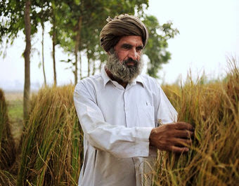
Rice Farmer in Punjab, India

"The impacts of climate change are likely to result in huge economic, social and environmental damage to South Asian countries, compromising their growth potential and poverty reduction efforts," said the study, published by the Asian Development Bank.

The cuts in regional GDP are so deep that they might ripple around the world, as six developing countries with 1.4 billion people—a third of them living in poverty—pay the price of the world's continuing reliance on fossil fuels.

Projections like this feed into the urgency for action as world leaders prepare to meet at the United Nations next month to discuss the climate crisis. Recent warnings show that the steps nations seem willing to take will fall well short of what is needed.

Action now, the study shows, would pay immediate and lasting dividends to the countries it examined: Bangladesh, Bhutan, India, the Maldives, Nepal and Sri Lanka.

The study, published as a new 160-page book, says that if the world cuts fossil fuel consumption enough to keep warming within 2 degrees Celsius—the goal of UN negotiations—the costs to South Asian countries of adapting to rising seas and temperatures in the decades ahead might be cut almost in half.

But if business-as-usual continues, leading to a world that is 4 or 5 degrees warmer by 2100 than at the start of the industrial age, the outlook looks grim.

"Climate change will slash up to 9 percent off the South Asian economy every year by the end of this century if the world continues on its current fossil-fuel intensive path," the bank said. "The human and financial toll could be even higher if the damage from floods, droughts, and other extreme weather events is included."

Because this kind of estimate is inherently imprecise, the bank warned that the real damage could be much worse than expected. Under business-as-usual trends, there is a one in 20 chance that South Asia will lose 24 percent of its annual GDP by the end of the century, the study found.

Paying to stave off those damages will cost these nations dearly, the study said.

To avoid the damage that is expected if the world takes no action on climate change, South Asia would have to spend nearly $40 billion per year by 2050 on adaptation measures, or nearly half a percentage point of average annual GDP. By 2100, the costs would have to increase to $73 billion per year, or roughly nine-tenths of a point of GDP.

If the world were to achieve the 2-degree warming goal established by UN negotiators at climate treaty talks in Copenhagen in 2009—a goal also at the heart of culminating talks set for Paris in 2015—annual adaptation costs for South Asia would be considerably less: $31 billion a year at mid-century, and $41 billion at century's end.

And instead of losing nearly 9 percent of annual GDP by the end of the century, the study found, South Asia would lose about 2.5 percent by 2100 if the world lives up to the goals of Copenhagen. More


Sunday, June 29, 2014

Himalayan Water Security: The Challenges for South and Southeast Asia

The scramble for control of natural resources to support economic and population growth, combined with the uncertain effects of climate change on the Tibetan Plateau, is raising tensions in Asia over Himalayan water resources.

Ten of the region’s largest and longest rivers (the Amu Darya, Brahmaputra, Ganges, Indus, Irrawaddy, Mekong, Salween, Tarim, Yangtze, and Yellow) originate in the Himalayas. These rivers help provide water, food, and energy for nearly 4 billion people in China and across South and Southeast Asia—nearly half of the world’s population. However, depletion and diversion of these transborder resources to meet growing industrial, agricultural, and urban demands have the potential to trigger far-reaching economic, social, and environmental challenges.

The lack of comprehensive and effective regional frameworks for cooperation hinders sustainable management of these waterways. China, which controls the headwaters of these rivers, has an enormous need for Himalayan water to satisfy economic and energy demands but has little incentive to participate in formal water-sharing and water-management agreements with its neighbors. China’s dam-building and water-diversion projects are a source of major concern to the countries downstream, which often complain about Beijing’s lack of transparency and reluctance to share information. Although managing water-sharing relations with China might be the most prominent challenge, cooperation is not much easier at the middle and lower reaches of the rivers. Collaboration in South and Southeast Asia is frequently frustrated by competing national interests, economic priorities, political disputes, and weak regional organizations. In addition to the environmental impacts of man-made diversion projects and unsustainable freshwater usage, there is also inadequate cooperation on scientific research to understand and prepare for the effects of climate change on the region’s water supplies.

This Asia Policy roundtable contains seven essays that discuss the challenges and implications of water security in Asia and recommend steps that both upstream and downstream countries could take to better manage the region’s shared water resources.

Asia’s Unstable Water Tower: The Politics, Economics, and Ecology of Himalayan Water Projects
Kenneth Pomeranz

China’s Upstream Advantage in the Great Himalayan Watershed
Jennifer L. Turner, Susan Chan Shifflett, and Robert Batten

Melting the Geopolitical Ice in South Asia
Robert G. Wirsing

Himalayan Water Security: A South Asian Perspective
Tushaar Shah and Mark Giordano

Hydropower Dams on the Mekong: Old Dreams, New Dangers
Richard P. Cronin

Climate Change and Water Security in the Himalayan Region
Richard Matthew

Securing the Himalayas as the Water Tower of Asia: An Environmental Perspective
Jayanta Bandyopadhyay

Download PDF


As I have been arguing for a number of years South Asia needs to re-negotiate the Indus Water Treaty to encompass Afghainstan, Bangladesh, Bhutan, China, India, Nepal and Pakistan before the region starts to suffer from water insecurity and the effects of climate change. Editor


Sunday, May 25, 2014

Nepal Glaciers Shrink By Quarter In 30 Years

Climate crisis has caused Nepal 's Himalayan glaciers to shrink by nearly a quarter in just over 30 years, said a scientist.

The glacier loss raises the risk of natural disasters in the ecologically fragile region.

A new study by the Kathmandu-based International Centre for Integrated Mountain Development (ICIMOD) shows that the area covered by glaciers has decreased by 24 per cent between 1977 and 2010.

Samjwal Ratna Bajracharya, lead author of the report, said “the shrinking of glaciers in Nepal is definitely connected to climate change; glacial melt is a huge indicator of rising temperatures.”

Under the three-year study led by ICIMOD scientists mapped satellite imagery from several decades to find the extent of ice loss in the region.

The fastest decline occurred between 1980 and 1990, said Bajracharya. Prior to the late 1970s, satellite imagery reflected little change in Nepal 's glacial area.

He said the glacial melting is creating huge, expanding lakes that threaten to burst and devastate mountain communities living downstream.

The accelerated glacial loss raises concerns over future access to water resources, particularly in regions where groundwater is limited and monsoon rains are erratic.

“If the trend continues, the immediate impact will be felt by those living in high-altitude regions, which are dependent on freshwater reserves from glaciers,” said Bajracharya.

The findings also sound alarm bells for Nepal 's push to develop hydropower projects.

“ Nepal cannot use its water resources to develop the country without assessing the state of our glaciers and river basins,” he said.

A government report in India recently blamed hydropower projects for devastating floods last year that killed thousands in India and Nepal .

The government panel said the build up of sediment in rivers, due to the dumping of soil that was dug up during construction of hydropower projects, exacerbated flooding when record-high rainfall hit the region last June.

It should be mentioned that the Himalayan region abounds in glaciers. Most of the big glaciers lie in the eastern Himalayas .

As the western Himalayas receive only a small amount of rainfall, barring the formation of vast snowfields, the source of some of the big rivers of Nepal are in fact glaciers.

Nepal 's largest glacier lies in the Mahalangur and the Kumbhakarna ranges. Khumbu is the biggest glacier and Langtang the longest. Kanchenjunga , Yalung, Nupchu and Langtang are some other glaciers belonging to the eastern Himalayas . Tukche and Hidden valley glaciers belong to the central Himalayas but these are comparatively small.

The Khumbu glacier is situated between Mount Everest and the Lhotse-Nuptse Ridge. It is seen flowing down between the two mountains and swerving right through the Khumbu valley. The terrain is gray and rocky. More


Monday, March 25, 2013

Tibetan Plateau glaciers shrinking

About 90 per cent of glaciers in the Third Pole region are shrinking, accelerated by black carbon being transferred from South Asia to the Tibetan Plateau, a top scientist has warned.

Change between 1968 and 2007

The Third Pole region, which is centred on the Tibetan Plateau and concerns the interests of the surrounding countries and regions, covers more than 5 million square kilometers and has an average altitude of more than 4,000 meters.

The area has the largest number of glaciers outside the polar regions and exerts a direct influence on the social and economic development of some of the most densely populated regions on earth, including China and India.

The glaciers are at the headwaters of many prominent Asian rivers.

Influenced by global warming, its alpine glaciers have seen drastic changes in recent years, such as thinning and shrinkage, which pose potential geological hazards to people both on and around the plateau.

Like Antarctica and the Arctic, the Third Pole is drawing increased attention from the international academic community, but the results of former international studies in this area are inconsistent, said Yao Tandong, director of the Chinese Academy of Sciences' Institute of Tibetan Plateau Research.

The scientist, a member of the Chinese People's Political Consultative Conference National Committee, said some people believe the glaciers will retreat and finally disappear by 2030, while others argue they will remain unchanged.

There are even people who argue that the glaciers have even moved forward, he said.

Researchers at Yao's institute say they can now draw a more comprehensive picture of the region, by showing data on the glaciers' status over the past 30 years. An investigation using topographic maps and satellite images revealed the retreat of 82 glaciers, area reduction by 7,090 glaciers and the mass-balance change of 15 glaciers.

"Systematic differences in glacier status are apparent from region to region, with the most pronounced shrinkage in the Himalayas, the southeastern part of the region.

Some of the glaciers there are very likely to disappear by 2030," Yao said. More


Saturday, March 2, 2013

Pacific Northwest and Himalayas Could Experience Major Earthquakes, Geophysicists Say

Dec. 4, 2012 — Research by Stanford scientists focuses on geologic features and activity in the Himalayas and Pacific Northwest that could mean those areas are primed for major earthquakes.

A big one in the Himalayas

The Himalayan range was formed, and remains currently active, due to the collision of the Indian and Asian continental plates. Scientists have known for some time that India is subducting under Asia, and have recently begun studying the complexity of this volatile collision zone in greater detail, particularly the fault that separates the two plates, the Main Himalayan Thrust (MHT).

Previous observations had indicated a relatively uniform fault plane that dipped a few degrees to the north. To produce a clearer picture of the fault, Warren Caldwell, a geophysics doctoral student at Stanford, has analyzed seismic data from 20 seismometers deployed for two years across the Himalayas by colleagues at the National Geophysical Research Institute of India.

The data imaged a thrust dipping a gentle two to four degrees northward, as has been previously inferred, but also revealed a segment of the thrust that dips more steeply (15 degrees downward) for 20 kilometers. Such a ramp has been postulated to be a nucleation point for massive earthquakes in the Himalaya.

Although Caldwell emphasized that his research focuses on imaging the fault, not on predicting earthquakes, he noted that the MHT has historically been responsible for a magnitude 8 to 9 earthquake every several hundred years.

"What we're observing doesn't bear on where we are in the earthquake cycle, but it has implications in predicting earthquake magnitude," Caldwell said. "From our imaging, the ramp location is a bit farther north than has been previously observed, which would create a larger rupture width and a larger magnitude earthquake."

Caldwell will present a poster detailing the research on Dec. 4 at the meeting of the American Geophysical Union in San Francisco.

Caldwell's adviser, geophysics Professor Simon Klemperer, added that recent detections of magma and water around the MHT indicate which segments of the thrust will rupture during an earthquake.

"We think that the big thrust vault will probably rupture southward to the Earth's surface, but we don't expect significant rupture north of there," Klemperer said. The findings are important for creating risk assessments and disaster plans for the heavily populated cities in the region.

Klemperer spoke about the evolution of geophysical studies of the Himalayas Dec. 3 at the same meeting in San Francisco.

Measuring small tremors in the Pacific Northwest

The Cascadia subduction zone, which stretches from northern California to Vancouver Island, has not experienced a major seismic event since it ruptured in 1700, an 8.7-9.2 magnitude earthquake that shook the region and created a tsunami that reached Japan. And while many geophysicists believe the fault is due for a similar scale event, the relative lack of any earthquake data in the Pacific Northwest makes it difficult to predict how ground motion from a future event would propagate in the Cascadia area, which runs through Seattle, Portland and Vancouver.

Stanford postdoctoral scholar Annemarie Baltay will present research on how measurements of small seismic tremors in the region can be utilized to determine how ground motion from larger events might behave. Baltay's research involves measuring low amplitude tectonic tremor that occurs 30 kilometers below Earth's surface, at the intersections of tectonic plates, roughly over the course of a month each year.

By analyzing how the tremor signal decays along and away from the Cascadia subduction zone, Baltay can calculate how ground motion activity from a larger earthquake will dissipate. An important application of the work will be to help inform new construction how best to mitigate damage should a large earthquake strike.

"We can't predict when an earthquake will occur, but we can try to be very prepared for them," Baltay said. "Looking at these episodic tremor events can help us constrain what the ground motion might be like in a certain place during an earthquake."

Though Baltay has focused on the Cascadia subduction zone, she said that the technique could be applied in areas of high earthquake risk around the world, such as Alaska and Japan. More


Friday, October 26, 2012

Tibet and the Future of Asia: Strategic Issues for the U.S., Pakistan, India, and the World

Tibet and the Future of Asia: Strategic Issues for the U.S., India, and the World

Published onMay 7, 2012byForeignPolicyI

3,337 views


33 likes, 1 dislikes
As the Obama administration pursues its "Asia pivot," Tibet is taking on increased strategic significance due to its importance as a source of water and minerals, the militarization of the Tibetan plateau and the Sino-Indian border, Chinese influence in Nepal, and Beijing's insistence on deference to its control of Tibet as a "core interest." The series of self-immolations by Tibetans over the past year demonstrates that 60 years of Communist Chinese occupation has not succeeded in destroying Tibetans' identity and desire for freedom. This still unfolding unrest and the democratization of the Tibetan government-in-exile make imperative a review of international policies.

Moving forward, what role will Tibet play in the region's peace and security? Do the U.S. and India have the right policies in place for Tibet? What policies is China pursuing in response to recent events and in anticipation of the future? What are the prospects for achieving the autonomy the Dalai Lama seeks? Can Tibetan Buddhism and democracy provide a bridge between Tibetans and Chinese?

Discussing these vital questions will be Brahma Chellaney of the Centre for Policy Research; Michael J. Green of the Center for Strategic and International Studies; Lodi G. Gyari, special envoy of His Holiness the Dalai Lama; and Ambassador Lalit Mansingh, former Indian Foreign Secretary. FPI Director of Democracy and Human Rights Ellen Bork will moderate the discussion.

Sunday, July 15, 2012

UNFCCC Executive Secretary Christiana Figueres statement at of International Conference of Mountain Countries on Climate Change

UNFCCC Executive Secretary Christiana Figueres delivers recorded video statement on occasion of the International Conference of Mountain Countries on Climate Change in Kathmandu on 5-6 April 2012